


There are now 23 countries in North America, as shown in the table below.
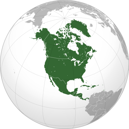
Name: North America, referred to as North America.
Location: Located in the northern Western Hemisphere. It is bordered by the Atlantic Ocean to the east, the Pacific Ocean to the west, the Arctic Ocean to the north, and the Panama Canal to the south and South America.
Area: 24.228 million square kilometers (including nearby islands), accounting for about 16.2% of the world's total land area, making it the third largest continent in the world.
Range: East to Cape St. Charles (55°40'W, 52°13'N), south to Cape Mariatoto (81°05'W, 7°12'N), west to Prince of Wales (168°05'W, 65°37'N), north to Cape Muchison (94°26'W, 71°59'N) on the Busia Peninsula. North America includes the West Indies in the Caribbean Sea, in addition to the Americas north of the Panama Canal.
Geographical area: divided into the eastern region (the Labrador Plateau east of the Appalachian Mountains), the central region (between the Labrador Plateau Appalachian Mountains and the Rocky Mountains), the western region (belonging to the northern section of the Cordillera Mountain System in the Americas, the Rocky Mountains are the skeleton of this area), Alaska, the Canadian Arctic Islands, Greenland, Mexico, Central America and the West Indies
Inhabitants: The distribution of the population across the continent is very uneven, with the vast majority of the population distributed in the southeast. It is home to 4/5 of the population of the United States and 2/3 of Canada, with the largest population density near New York and Lake Erie between the United States and Canada. Puerto Rico and Martinique in the West Indies are also densely populated areas. The vast northern region and the interior of the western United States are sparsely populated, and in some cases even uninhabited. The residents are mainly descendants of immigrants from European countries such as Britain and France. This was followed by blacks, Indians, mestizos, and a small number of Greenlanders, Puerto Ricans, Ditters, Japanese and the Chinese diaspora. Mainly Christian and Catholic. General English and Spanish.
Natural resources: North America is rich in mineral resources, mainly oil, natural gas, coal, sulfur, iron, copper, nickel, uranium, lead, zinc, etc. Forest resources are mainly distributed in the western mountains, rich in yellow cedar, sequoia, giant sequoia, hemlock chips, and the southern part produces rosewood and other high-quality wood. The waters around the Caribbean Sea and Newfoundland are world-famous fishing grounds.
Economic Summary: North America is one of the industrially developed regions of the world. There is a high degree of specialization, commercialization and mechanization of agricultural production. The mining industry is relatively large-scale, mainly mining coal, crude oil, natural gas, iron, copper, lead, zinc, sulfur, etc., while tin, manganese, cobalt, aluminum, diamond, tantalum, niobium and other important strategic raw materials are almost all or mostly imported. The Central Plain of North America is one of the world's famous agricultural areas, crops are mainly corn, wheat, rice, cotton, soybeans, tobacco, soybeans, corn, wheat production occupies an important position in world agriculture. The countries of Central America and the West Indies mainly produce tropical crops such as sugar cane, bananas, coffee, and cocoa.
In addition, there are: Greenland, Netherlands Aruba, British Anguilla, British Bermuda, United States Federal Territory Puerto Rico, French overseas province Guadeloupe, Netherlands Antilles (excluding Aruba), British Cayman Islands, French overseas department Martinique, American Virgin Islands, British Turks and Caicos Islands, British Virgin Islands, etc.
North America, full name North America, is located in the northern part of the Western Hemisphere and is the second most developed continent in the world economy, of which the United States economy ranks first in the world and has important influence in the global economy and politics. Most of North America belongs to developed countries, with a very high human development index and economic development level. General English, followed by Spanish, French, Dutch, Native American languages, etc.
North America has a total area of 24.228 million square kilometers (including nearby islands), accounting for about 16.2% of the world's total land area, making it the third largest continent in the world. It is bordered by the Atlantic Ocean to the east, the Pacific Ocean to the west, the Arctic Ocean to the north, the Panama Canal to the south and South America, and the Danish Strait to the northeast to Europe. The mainland extends east to Cape St. Charles (55°40'W, 52°13'N), south to Cape Mariato (81°05'W, 7°12'N), west to Prince of Wales (168°05'W, 65°37'N), and north to Cape Muchison on the Busia Peninsula (94°26'W, 71°59'N).
The outflow area
of North America accounts for about 88% of the continent, of which the Atlantic basin accounts for about 48% of the continent and the Pacific basin accounts for about 20%. With the exception of the St. Lawrence River, all major rivers originate in the Rocky Mountains. Rivers east of the Rocky Mountains flow into the Atlantic and Arctic Oceans, respectively, and rivers to the west flow into the Pacific Ocean. The inflow area (including the non-flow zone) accounts for about 12% of the continent, mainly in the Great Basin of the western United States and Greenland. The Mississippi River is the largest river in North America and the fourth largest river in the world by length. This is followed by the Maggenzie River, the Yukon River, the St. Lawrence River and the Rio Grande. Other important rivers are: Colorado River, Ohio River, Columbia River, etc.
There are many waterfalls on the rivers of North America, and the largest waterfall is Yosemite Falls in Yosemite National Park in the western United States, with a drop of 739 meters. Niagara Falls, drop 54 meters, width 1160 meters. North America is a multi-lake continent, with a total area of about 400,000 square kilometers of freshwater lakes, ranking first among all continents. The lakes are mainly distributed in the northern half of the continent. The five great lakes in the Central Plateau: Lake Superior, Lake Huron, Lake Michigan, Lake Erie, Lake Ontario, with a total area of 245273 square kilometers, are the world's largest freshwater lakes, known as the "North American Mediterranean". Among them, Lake Superior is the largest and the largest freshwater lake in the world.
Climate
North America spans tropical, temperate and cold zones, and the climate is complex and diverse. It mainly has a temperate continental climate and a subarctic coniferous forest climate. The northern part is within the Arctic Circle, the world of ice and snow. The southern Caribbean Sea is affected by the warm equatorial current, but is hit by tropical hurricanes. The vast area in the central part of the continent is located in the northern temperate zone, which is suitable for crop growth and human survival.
Since all mountains run north-south or approximately north-south, the humid air from the Pacific Ocean reaches only the western coastal areas; Cold air from the Arctic Ocean can drive south through the central plains; The humid air blowing from the tropical Atlantic Ocean can also pass through the central plains and deep into the north, so the climate in North America is very unstable, with winters sometimes cold and sometimes thawing, and severe cold and snow in the subtropical areas of the Gulf Coast.
The coldest month in North America (January) has an average temperature below 0 °C, accounting for about 3/4 of the continent's area, the entire Arctic archipelago (a general term for many islands north of the North American continent and west of Greenland) and most of Greenland are below -32 °C, and the central Greenland is as low as -50 °C, becoming the cold polar region of the Western Hemisphere. In summer, the whole continent is generally warming, and the average temperature of the hottest month (July, mostly August along the coast) is 0~3 °C in central Greenland, becoming the coolest area in the northern hemisphere in summer; The rest of the vast areas are between 0-32 °C, of which areas above 20 °C account for more than half of the continent's area, and areas above 30 °C are smaller. In Death Valley in the southwestern United States, the extreme maximum temperature once reached 56.7 degrees Celsius, which is the hottest region in the continent. Precipitation is heavier in eastern North America.
The annual precipitation in the southeast of Canada and Greenland, the eastern part of the United States, and the Pacific coast of Canada and Alaska is about 500~300 mm; Canada and Alaska, with their Pacific coast reaching more than 2,000 mm, are the wettest areas in North America; The annual precipitation of the Florida Peninsula is 1000-1500 mm, and the annual precipitation of the eastern foothills of the Rocky Mountains, the Great Plains and the Yukon Plateau is 250~100 mm; The Caribbean has a tropical rainforest climate with high temperatures and rain throughout the year. The areas with the lowest precipitation are in the southwestern Great Basin of the United States, the lower Colorado River, and the northern part of the Arctic Islands and Greenland, with average annual precipitation of less than 100 mm. Every May, southeastern North America is hit by hurricanes, often causing severe damage. Winters in central and northern North America often blow cold and intense storms and land tornadoes. After crossing the Rocky Mountains, westerly winds form the Chinnock wind at the eastern foothills.
The coastline
of the mainland is about 60,000 kilometers long. The northern, northern and eastern coasts of the west are more tortuous, with many islands and fjords; The southern half of the coast is straighter.
The total area of the peninsula and island
peninsula is about 2.1 million square kilometers. With a total area of about 4 million square kilometres, the island is the largest among all continents. Greenland is the largest island in the world, 80% covered with glaciers, and is a Danish colony. In a 2015 paper published in
the academic journal The Professional Geographer, Rogerson proposed a new way to define the center of spatial entities. This approach improves on past techniques, he says, taking into account the curvature of the Earth, using definitions (sound mathematics) to identify geographic centers. Rogerson used a technique geographers called equidistant azimuth projection, which equals the area on the map to the corresponding actual ground area when a circular three-dimensional portion of the Earth is projected into a two-dimensional plane.
In late 2016, he used this approach to find the heart of North America. The result was serendipitous: according to his calculations, the center of the North American continent was in oneA place called Center, a town of 570 people in North Dakota.
The total population is 528,720,000 (2008), which is about 8% of the world's total population
. The population distribution across the continent is very uneven, with the vast majority of the population distributed in the southeast and southwest coastal areas, with the largest population density near New York and around Lake Erie, with more than 200 people per square kilometer. The vast northern region and the interior of the western United States are sparsely populated, and in some cases even uninhabited, with less than one person per square kilometer.
Terrain:
Plains below 200 meters above sea level account for about 20%, plains and hills at altitude of 200-500 meters account for about 22%, plateaus and mountains above 500 meters above sea level account for about 58%, and the average altitude of the continent is 700 meters. The basic characteristics of the continental topography are that the mountains running north-south are distributed on the east and west sides parallel to the coast, and the Great Plains are distributed in the middle. The terrain is clearly divided into three zones.
Eastern Mountains and Highlands: The Labrador Plateau to the north of the St. Lawrence River and the Appalachian Mountains to the south, the terrain is high in the south and low in the north, and the altitude is generally 300-500 meters. The Appalachian Mountains have a narrow coastal plain along the Atlantic Ocean on the eastern side, and the western side gradually descends to meet the central plain.
Central Plains: Located between the Labrador Plateau, Appalachian Mountains and Rocky Mountains, it stretches from Hudson Bay in the north to the Gulf of Mexico in the south, running through the middle of the continent. The northern half of the plain is rich in lakes and rapids, and the southern half is part of the Mississippi River Plain. The western part of the plain is the world-famous Great Plain.
Western mountains and plateaus: belong to the northern section of the Cordillera mountain system, stretching from Alaska to the south of Mexico, mainly including three parallel mountains, the eastern belt is the Rocky Mountains above 2000-3000 meters above sea level, extending 5000 kilometers from north to south, which is an important dividing line in the climate of North America; The western belt extends from the coastal mountains of the United States in the south to the sea in the north, forming the coastal islands of western Canada, generally 500-1000 meters above sea level; The Middle Belt includes the Alaska Mountains in the north, the Coast Mountains in Canada, the Sierra Nevada and the Cascade Ridge in the United States. Mount McKinley in Alaska, USA, is the highest peak in North America at 6193 meters above sea level.
Between the eastern and middle belts are plateaus and basins, the bottom of the large basin is 800-1300 meters above sea level, and the southern Death Valley of the basin is 86 meters below sea level, which is the lowest point of the land in the Western Hemisphere. North America has a high average altitude and a large undulating terrain, and the terrain is divided into three north-south vertical belts: tall mountains in the west, vast plains in the middle, and gentle highlands in the east. [3] Volcanoes and Earthquakes
,
the western coast of North America is part of the Pacific Coast Volcanic Belt. There are more than 90 active volcanoes in North America, including 28 in the Aleutian Islands, 20 in Alaska and more than 40 in Central America. Western North America is also home to frequent and intense earthquakes in the world.
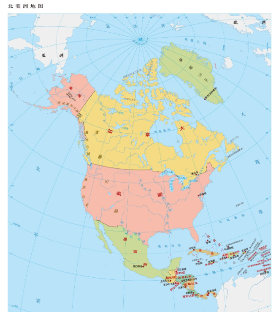
| country | capital |
| United States | Washington, D.C |
| Canada | Ottawa |
| Mexico | Mexico City |
| Guatemala | Guatemala City |
| Belize | Belmopan |
| El Salvador | San Salvador |
| Honduras | Tegucigalpa |
| Panama | Panama City |
| Bahamas | Nassau |
| Cuba | Havana |
| Jamaica | Kingston |
| Haiti | Port-au-Prince |
| dominica | Santo Domingo |
| Costa Rica | San jose |
| Saint Kitts and Nevis | Basseterre |
| Antigua and Barbuda | St. John |
| Dominica | Roseau |
| Saint Lucia | Castries |
| Saint Vincent and the Grenadines | Kingston |
| Barbados | Bridgetown |
| Grenada | St. George |
| Trinidad and Tobago | Port of Spain |
| Nicaragua | Managua |
Name: North America, referred to as North America.
Location: Located in the northern Western Hemisphere. It is bordered by the Atlantic Ocean to the east, the Pacific Ocean to the west, the Arctic Ocean to the north, and the Panama Canal to the south and South America.
Area: 24.228 million square kilometers (including nearby islands), accounting for about 16.2% of the world's total land area, making it the third largest continent in the world.
Range: East to Cape St. Charles (55°40'W, 52°13'N), south to Cape Mariatoto (81°05'W, 7°12'N), west to Prince of Wales (168°05'W, 65°37'N), north to Cape Muchison (94°26'W, 71°59'N) on the Busia Peninsula. North America includes the West Indies in the Caribbean Sea, in addition to the Americas north of the Panama Canal.
Geographical area: divided into the eastern region (the Labrador Plateau east of the Appalachian Mountains), the central region (between the Labrador Plateau Appalachian Mountains and the Rocky Mountains), the western region (belonging to the northern section of the Cordillera Mountain System in the Americas, the Rocky Mountains are the skeleton of this area), Alaska, the Canadian Arctic Islands, Greenland, Mexico, Central America and the West Indies
Inhabitants: The distribution of the population across the continent is very uneven, with the vast majority of the population distributed in the southeast. It is home to 4/5 of the population of the United States and 2/3 of Canada, with the largest population density near New York and Lake Erie between the United States and Canada. Puerto Rico and Martinique in the West Indies are also densely populated areas. The vast northern region and the interior of the western United States are sparsely populated, and in some cases even uninhabited. The residents are mainly descendants of immigrants from European countries such as Britain and France. This was followed by blacks, Indians, mestizos, and a small number of Greenlanders, Puerto Ricans, Ditters, Japanese and the Chinese diaspora. Mainly Christian and Catholic. General English and Spanish.
Natural resources: North America is rich in mineral resources, mainly oil, natural gas, coal, sulfur, iron, copper, nickel, uranium, lead, zinc, etc. Forest resources are mainly distributed in the western mountains, rich in yellow cedar, sequoia, giant sequoia, hemlock chips, and the southern part produces rosewood and other high-quality wood. The waters around the Caribbean Sea and Newfoundland are world-famous fishing grounds.
Economic Summary: North America is one of the industrially developed regions of the world. There is a high degree of specialization, commercialization and mechanization of agricultural production. The mining industry is relatively large-scale, mainly mining coal, crude oil, natural gas, iron, copper, lead, zinc, sulfur, etc., while tin, manganese, cobalt, aluminum, diamond, tantalum, niobium and other important strategic raw materials are almost all or mostly imported. The Central Plain of North America is one of the world's famous agricultural areas, crops are mainly corn, wheat, rice, cotton, soybeans, tobacco, soybeans, corn, wheat production occupies an important position in world agriculture. The countries of Central America and the West Indies mainly produce tropical crops such as sugar cane, bananas, coffee, and cocoa.
In addition, there are: Greenland, Netherlands Aruba, British Anguilla, British Bermuda, United States Federal Territory Puerto Rico, French overseas province Guadeloupe, Netherlands Antilles (excluding Aruba), British Cayman Islands, French overseas department Martinique, American Virgin Islands, British Turks and Caicos Islands, British Virgin Islands, etc.
North America, full name North America, is located in the northern part of the Western Hemisphere and is the second most developed continent in the world economy, of which the United States economy ranks first in the world and has important influence in the global economy and politics. Most of North America belongs to developed countries, with a very high human development index and economic development level. General English, followed by Spanish, French, Dutch, Native American languages, etc.
North America has a total area of 24.228 million square kilometers (including nearby islands), accounting for about 16.2% of the world's total land area, making it the third largest continent in the world. It is bordered by the Atlantic Ocean to the east, the Pacific Ocean to the west, the Arctic Ocean to the north, the Panama Canal to the south and South America, and the Danish Strait to the northeast to Europe. The mainland extends east to Cape St. Charles (55°40'W, 52°13'N), south to Cape Mariato (81°05'W, 7°12'N), west to Prince of Wales (168°05'W, 65°37'N), and north to Cape Muchison on the Busia Peninsula (94°26'W, 71°59'N).
The outflow area
of North America accounts for about 88% of the continent, of which the Atlantic basin accounts for about 48% of the continent and the Pacific basin accounts for about 20%. With the exception of the St. Lawrence River, all major rivers originate in the Rocky Mountains. Rivers east of the Rocky Mountains flow into the Atlantic and Arctic Oceans, respectively, and rivers to the west flow into the Pacific Ocean. The inflow area (including the non-flow zone) accounts for about 12% of the continent, mainly in the Great Basin of the western United States and Greenland. The Mississippi River is the largest river in North America and the fourth largest river in the world by length. This is followed by the Maggenzie River, the Yukon River, the St. Lawrence River and the Rio Grande. Other important rivers are: Colorado River, Ohio River, Columbia River, etc.
There are many waterfalls on the rivers of North America, and the largest waterfall is Yosemite Falls in Yosemite National Park in the western United States, with a drop of 739 meters. Niagara Falls, drop 54 meters, width 1160 meters. North America is a multi-lake continent, with a total area of about 400,000 square kilometers of freshwater lakes, ranking first among all continents. The lakes are mainly distributed in the northern half of the continent. The five great lakes in the Central Plateau: Lake Superior, Lake Huron, Lake Michigan, Lake Erie, Lake Ontario, with a total area of 245273 square kilometers, are the world's largest freshwater lakes, known as the "North American Mediterranean". Among them, Lake Superior is the largest and the largest freshwater lake in the world.
Climate
North America spans tropical, temperate and cold zones, and the climate is complex and diverse. It mainly has a temperate continental climate and a subarctic coniferous forest climate. The northern part is within the Arctic Circle, the world of ice and snow. The southern Caribbean Sea is affected by the warm equatorial current, but is hit by tropical hurricanes. The vast area in the central part of the continent is located in the northern temperate zone, which is suitable for crop growth and human survival.
Since all mountains run north-south or approximately north-south, the humid air from the Pacific Ocean reaches only the western coastal areas; Cold air from the Arctic Ocean can drive south through the central plains; The humid air blowing from the tropical Atlantic Ocean can also pass through the central plains and deep into the north, so the climate in North America is very unstable, with winters sometimes cold and sometimes thawing, and severe cold and snow in the subtropical areas of the Gulf Coast.
The coldest month in North America (January) has an average temperature below 0 °C, accounting for about 3/4 of the continent's area, the entire Arctic archipelago (a general term for many islands north of the North American continent and west of Greenland) and most of Greenland are below -32 °C, and the central Greenland is as low as -50 °C, becoming the cold polar region of the Western Hemisphere. In summer, the whole continent is generally warming, and the average temperature of the hottest month (July, mostly August along the coast) is 0~3 °C in central Greenland, becoming the coolest area in the northern hemisphere in summer; The rest of the vast areas are between 0-32 °C, of which areas above 20 °C account for more than half of the continent's area, and areas above 30 °C are smaller. In Death Valley in the southwestern United States, the extreme maximum temperature once reached 56.7 degrees Celsius, which is the hottest region in the continent. Precipitation is heavier in eastern North America.
The annual precipitation in the southeast of Canada and Greenland, the eastern part of the United States, and the Pacific coast of Canada and Alaska is about 500~300 mm; Canada and Alaska, with their Pacific coast reaching more than 2,000 mm, are the wettest areas in North America; The annual precipitation of the Florida Peninsula is 1000-1500 mm, and the annual precipitation of the eastern foothills of the Rocky Mountains, the Great Plains and the Yukon Plateau is 250~100 mm; The Caribbean has a tropical rainforest climate with high temperatures and rain throughout the year. The areas with the lowest precipitation are in the southwestern Great Basin of the United States, the lower Colorado River, and the northern part of the Arctic Islands and Greenland, with average annual precipitation of less than 100 mm. Every May, southeastern North America is hit by hurricanes, often causing severe damage. Winters in central and northern North America often blow cold and intense storms and land tornadoes. After crossing the Rocky Mountains, westerly winds form the Chinnock wind at the eastern foothills.
The coastline
of the mainland is about 60,000 kilometers long. The northern, northern and eastern coasts of the west are more tortuous, with many islands and fjords; The southern half of the coast is straighter.
The total area of the peninsula and island
peninsula is about 2.1 million square kilometers. With a total area of about 4 million square kilometres, the island is the largest among all continents. Greenland is the largest island in the world, 80% covered with glaciers, and is a Danish colony. In a 2015 paper published in
the academic journal The Professional Geographer, Rogerson proposed a new way to define the center of spatial entities. This approach improves on past techniques, he says, taking into account the curvature of the Earth, using definitions (sound mathematics) to identify geographic centers. Rogerson used a technique geographers called equidistant azimuth projection, which equals the area on the map to the corresponding actual ground area when a circular three-dimensional portion of the Earth is projected into a two-dimensional plane.
In late 2016, he used this approach to find the heart of North America. The result was serendipitous: according to his calculations, the center of the North American continent was in oneA place called Center, a town of 570 people in North Dakota.
The total population is 528,720,000 (2008), which is about 8% of the world's total population
. The population distribution across the continent is very uneven, with the vast majority of the population distributed in the southeast and southwest coastal areas, with the largest population density near New York and around Lake Erie, with more than 200 people per square kilometer. The vast northern region and the interior of the western United States are sparsely populated, and in some cases even uninhabited, with less than one person per square kilometer.
Terrain:
Plains below 200 meters above sea level account for about 20%, plains and hills at altitude of 200-500 meters account for about 22%, plateaus and mountains above 500 meters above sea level account for about 58%, and the average altitude of the continent is 700 meters. The basic characteristics of the continental topography are that the mountains running north-south are distributed on the east and west sides parallel to the coast, and the Great Plains are distributed in the middle. The terrain is clearly divided into three zones.
Eastern Mountains and Highlands: The Labrador Plateau to the north of the St. Lawrence River and the Appalachian Mountains to the south, the terrain is high in the south and low in the north, and the altitude is generally 300-500 meters. The Appalachian Mountains have a narrow coastal plain along the Atlantic Ocean on the eastern side, and the western side gradually descends to meet the central plain.
Central Plains: Located between the Labrador Plateau, Appalachian Mountains and Rocky Mountains, it stretches from Hudson Bay in the north to the Gulf of Mexico in the south, running through the middle of the continent. The northern half of the plain is rich in lakes and rapids, and the southern half is part of the Mississippi River Plain. The western part of the plain is the world-famous Great Plain.
Western mountains and plateaus: belong to the northern section of the Cordillera mountain system, stretching from Alaska to the south of Mexico, mainly including three parallel mountains, the eastern belt is the Rocky Mountains above 2000-3000 meters above sea level, extending 5000 kilometers from north to south, which is an important dividing line in the climate of North America; The western belt extends from the coastal mountains of the United States in the south to the sea in the north, forming the coastal islands of western Canada, generally 500-1000 meters above sea level; The Middle Belt includes the Alaska Mountains in the north, the Coast Mountains in Canada, the Sierra Nevada and the Cascade Ridge in the United States. Mount McKinley in Alaska, USA, is the highest peak in North America at 6193 meters above sea level.
Between the eastern and middle belts are plateaus and basins, the bottom of the large basin is 800-1300 meters above sea level, and the southern Death Valley of the basin is 86 meters below sea level, which is the lowest point of the land in the Western Hemisphere. North America has a high average altitude and a large undulating terrain, and the terrain is divided into three north-south vertical belts: tall mountains in the west, vast plains in the middle, and gentle highlands in the east. [3] Volcanoes and Earthquakes
,
the western coast of North America is part of the Pacific Coast Volcanic Belt. There are more than 90 active volcanoes in North America, including 28 in the Aleutian Islands, 20 in Alaska and more than 40 in Central America. Western North America is also home to frequent and intense earthquakes in the world.